
Having completed the South West Coast Path in September 2025, and even reprised the first section so that Tracy could complete it too, it was time for a new challenge.
So, at the end of June 2026, we began the Pembrokeshire Coast Path.
It extends 186 miles (299 kilometres) between St Dogmaels, near Cardigan, and Amroth, east of Tenby and Saundersfoot.
We provisionally plan to complete it in four week-long visits, basing ourselves at the optimal locations for travelling by public transport.
It might take us a few years to squeeze in these visits alongside our other commitments!

On this occasion we were able to use public transport throughout the week, relying heavily on the scheduled services and to some extent on Fflecsi (the flexibus service), though we found that very ‘hit and miss’.
Booked services always turned up, but it frequently wasn’t possible to book the services one required, when one required them.
Despite the restrictions imposed on us by bus timetables, we managed to complete approximately 42.5 miles of the Coast Path during this first week, so we are broadly on target.

Our walking programme turned out as follows:
- Tuesday: St Dogmaels to Ceibwr Beach (including walking from Cardigan to the start at St Dogmaels and inland from Ceibwr to the bus stop at Moylegrove);
- Wednesday: Ceibwr Beach to Newport Parrog (including the walks from Moylegrove to Ceibwr and Parrog to Newport);
- Thursday: Newport Parrog to Lower Fishguard (including the walk from Newport down to Parrog);
- Friday: Lower Fishguard to Strumble Head;
- Saturday: Strumble Head to Abercastle.

On that last day we would have made it to Trefin, slightly further on, but we got far too distracted by seals, so would have missed our bus connection.
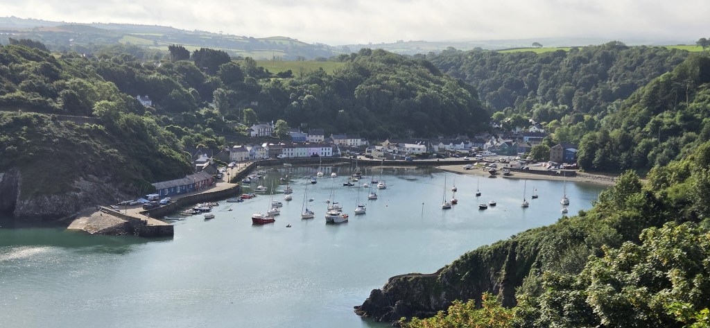
For this first week, we’d chosen Lower Fishguard as our base, arriving at our AirB’n’B on the last Monday in June and departing on the first Monday in July.
That meant I was away from home on 4 July 2026, otherwise known as #kateday26, the ninth anniversary of my wife’s final birthday.
So I dedicate this first Pembrokeshire Coast Path post to her memory.

Getting there
We travelled in to London Paddington via rail and tube, changing from one to the other at Wimbledon.
The steps between the rail platforms and the walkway are segregated: those climbing are kept on one side; those descending on another.
The train disgorged quite a crowd, which formed a slow-moving queue up the ascending steps, though that didn’t deter a man from trying to force his way downwards on the wrong side.
But he came to a sudden halt when his his knee collided with my suitcase.
It is a small, soft suitcase, but he cursed violently, and seemed in great discomfort.
Though concerned about his damaged patella which, nevertheless, he thoroughly deserved, I couldn’t apologise, commiserate or administer first aid, since the queue was propelling me ever upwards.
Arriving in good time at Paddington, we bought sandwiches and coffee before boarding the 10:48 departure to Swansea. It was announced early, so we managed to beat the crowds and were safely ensconced around a table before the carriage became crowded.
A family of four on the opposite side of the aisle switched effortlessly between French and American. They seemed to be embarking on the Welsh leg of a European tour, and perma-snacked their way from Paddington to the Principality.
We needed to change trains at either Newport (Gwent) or Swansea.
I argued for Swansea, since we were very comfortable, with a table to ourselves, a window and working internet.
Tracy strongly favoured an earlier change at Newport, for reasons she didn’t express too clearly.
I was unable to dent this firm conviction, my counter arguments proving ineffectual.
So I reluctantly followed orders…
…Only to discover that we were awaiting a delayed service, abbreviated from four coaches to two, because half the usual complement had been allocated ‘other priorities’.
We managed to squeeze aboard with our cases, and were extremely fortunate to find the last two seats available in our coach. I sulked a little, explaining to our new neighbours that we’d had a ‘domestic’ over where to change trains.

The service grew slightly less congested once we reached Swansea, where the train changed direction.
It took us approximately three hours to reach Fishguard and Goodwick, arriving at 15:25.
Rather than wait for a bus, we decided to stretch our legs by walking with our luggage through central Fishguard and then down to the Lower Town.
A kindly old gentleman offered Tracy tips about where to eat in St David’s, when eventually we reached there.
It took us about 45 minutes, round the seafront at Goodwick and then up some steps and into Town.
We paused on the way to inquire after a booking Tracy had tried to make at a particularly relaxed eatery.
We found our Air’B’n’B without difficulty, opened the key safe successfully and unpacked. We sampled the Welsh cakes kindly left us by our host. Shortly afterwards our pre-booked Co-op delivery arrived.
We were staying at Mill House, part of a ‘converted 18th Century mill complex’ containing four properties.
There was more than sufficient space for us and we had everything we needed (though a cafetiere and a pair of scissors wouldn’t have gone amiss).
The advertisement promised ‘half an acre of private, fully enclosed gardens’ including ‘a large BBQ grill, dining table and chairs for 6. Along with a fire pit to complete the peaceful vibe.’
We could see the barbecue and dining furniture next to the wall of a neighbouring property, but much of the promised garden had apparently disappeared under a newly-built bungalow. One corner remained, containing a park bench.
We began our customary ‘orientation walk’, which took us past the Lower Town Playground bus stop, the Ship Inn, the Yacht Club and on to the end of the Quay.

Here we found a dog, two women and a man flying his drone over the sea. Tracy was curious to see the pictures it was transmitting.
Returning the way we had come (for there is no alternative) we crossed the bridge and walked along the other side of the Harbour, following a small section of coast path before climbing to the Town Centre once more.

We made a few additional purchases at the Co-op, having omitted a few items from our order because unsure about what would be supplied at the house.
Then we crossed to the Royal Oak for drinks and dinner. I had fish pie, then apple crumble tart and ice cream; Tracy had fish and chips followed by crumble tart.
My pint of Felinfoel Double Dragon had me reminiscing about a trip I took to Wales with UEA friends Chris and Geoff, way back in 1979.
I vaguely remember a great deal of rain, and a pub in the mountains surrounded by slate mines where one poured one’s beer from the barrel.

Fishguard
Fishguard is really three places in one, though Lower Fishguard is part of Fishguard while Goodwick is distinct. (That said, Fishguard and Goodwick share a Town Council.)
The English name is derived from the Old Norse meaning ‘enclosure for catching fish’.
The Welsh name is Abergwaun, meaning ‘mouth of the River Gwaun’. The Gwaun is just nine miles long and flows into the sea under the bridge at Lower Fishguard.
Lower Fishguard is thought to have emerged as a Norse trading settlement in the decades immediately prior to 1000 AD. Conversely, the early medieval town developed at the top of the hill, close to the present High Street.

Lower Fishguard evolved into a trading port and herring fishery. By the late Eighteenth Century there were some 50 vessels based here, either fishing or trading predominantly with Bristol, Liverpool and various Irish ports.
In 1778 Lower Fishguard was attacked by ‘Black Prince’ an American privateer sailing under a French flag, under the command of Captain Stephen Manhant.
He tried to extort a ransom of £1,000 and, when payment was refused, opened fire with his ship’s cannon.
Local men prepared for a skirmish, anticipating a landing party, but Manhant decided that prevailing conditions made this too risky and ultimately withdrew.
The construction of Fishguard Fort (see below) was authorised as a consequence.

Almost two decades later, in February 1797, the area was briefly ‘invaded’ by a force from Revolutionary France. This is often celebrated as the last invasion of mainland Britain.
Though originally envisaged as a three-pronged attack, focused primarily on Ireland, this secondary, diversionary invasion was the only element that went ahead. Indiscipline and very poor weather were to blame.
The French force consisted of around 1,400 troops, of which only about 600 were regular soldiers. They were supported by two warships and two smaller vessels. The force landed in darkness at Carreg Gwastad Point, some three miles from Fishguard.
They were confronted by a force of roughly 600 local militia, reservists and sailors, under the command of John Campbell, first Baron Cawdor (c.1753-1821).

He made preparations to attack the French, but called off the engagement because it was growing dark. This was fortunate since a French contingent was lying in ambush.
Even so, that very evening, two French officers arrived at the Royal Oak on Fishguard Square, where Baron Cawdor had headquartered himself, and proposed a conditional surrender.
They had been spooked by the mass desertion and mutiny of most of their 800 or so irregular troops, many of whom were convicts.
Cawdor counter-proposed an unconditional French surrender on Goodwick Sands by 10:00 the next morning.

Despite a few hours’ delay, the French eventually complied.
Though some were briefly imprisoned at Haverfordwest, most were returned to France in a prisoner exchange the following year.
According to Welsh folk legend, one Jemima Nicholas (1755-1832), a cobbler’s wife, led a group of women who impersonated soldiers, tricking the French into thinking they were outnumbered.
She is also reputed to have captured twelve drunken French soldiers, armed only with a pitchfork, holding them captive in a church overnight.
Jemima is much celebrated hereabouts, not least through a commemorative stone in the local churchyard, but, although she definitely existed, there is no firm evidence for the escapades attributed to her.

In 1893, the Fishguard Bay Railway and Pier Company was granted permission to establish Fishguard Harbour and run a steamer service to Rosslare. The first commercial ferry service began in 1906.
In April 1912 the first successful flight between Britain and Ireland took place from a field near Goodwick to another near Enniscorthy in County Wexford. It was undertaken by Irish aviator Denys Corbett Wilson (1882-1915).
In June 1941 the passenger steamer St Patrick was running between Rosslare and Fishguard when she was sunk by a German bomber, some twelve miles off Fishguard.
Of the 89 people on board, 30 lost their lives. Captain James Faraday of Goodwick was killed when the bombs exploded.
During the Second World War an outfit from the Special Operations Executive was based at the Fishguard Bay Hotel, from where it tested various mini-submersible craft.
In 1955 Lower Fishguard was used as a location for the filming of Moby Dick, featuring Gregory Peck and Orson Welles.
And, in 1971, it featured as Llareggub in the film version of Under Milk Wood, starring Richard Burton and Elizabeth Taylor.
Cerys Matthews also went to school in Fishguard but, otherwise, few major celebrities are associated with the Town.

Tuesday: St Dogmaels to Ceibwr Beach
We waited with some trepidation at Lower Town Playground for the 08:59 Traws Cymru T5 bus, which runs all the way from Haverfordwest to Aberystwyth, but it arrived almost exactly on time.
It would take us to Cardigan, from where we would walk to neighbouring St Dogmaels.
We shared the bus with several old ladies, anxious to catch up with each other. Two, in particular, hadn’t met for some time.
They explained why they were no longer driving: one had experienced a health scare; the other had lost her confidence and decided she had become a hazard to other drivers.
We reached Cardigan in just over half an hour. It seemed an interesting, characterful place, but we had no time to investigate its attractions, which properly belong to Ceredigion rather than Pembrokeshire.

We walked swiftly from Finch Square, across the River Teifi and along the St Dogmaels Road. It began to rain, off and on, some fairly sharp showers alternating with brief dry spells.
Continuing along Pilot Road, we passed the Ferry Inn, finally reaching the start of the Coast Path, near a small landing stage.

It is marked by a low pillar and a mosaic placed here in July 2009.

There is also a weathered wooden statue.

The first official stage of the Path is over 15 miles long and is officially described as the most challenging, containing may steep hills.
Quite why it was felt necessary to begin with a marathon is nowhere explained.
Like many others, no doubt, we had decided to break it into two sections, taken over successive days.
For there is no point in tiring oneself to the point of being unable to appreciate the surrounding natural beauty.
St Dogmaels (known to the Welsh as Llandudoch) lies just over the Cardiganshire-Pembrokeshire border.
Dogmael was a Sixth Century monk of royal descent.
The ruins of St Dogmael’s Abbey stand on a hill above the Village. It was founded early in the Twelfth Century, and probably occupies the site of an earlier monastery established by Dogmael himself.

The Abbey was administered by the Tironesian Order which, though created in France only a decade earlier, had quickly established over 100 abbeys and priories across France, England, Scotland and Ireland. This was their first house in Wales.
It eventually fell a victim of the Dissolution, by which time only nine monks remained.
The property fell into the hands of one John Bradshaw, who converted it into a mansion house where his descendants remained for a century or more. Thereafter, it passed through the hands of several owners before ending up with The Commission of Works in 1934.
The ruins are Grade 1 listed.
The route follows the B4546 out of St Dogmaels, running parallel with the western side of the Teifi Estuary.
On the opposite side we could see the Water’s Edge Leisure Park, just below Gwbert, poking into the waters on its triangular peninsula.

Hundreds of geese perched on the sandflats next to the River.

Eventually we were directed along a path, following the edge of sand dunes, around the curve of the coast to Poppit Sands Beach.
Outside the Café we found the plaque marking the original start of the Coast Path, and its opening by journalist and broadcaster Wynford Vaughan Thomas (1908-1987) on 16 May 1970.

The trail was then several miles shorter, at 180 miles exactly.
There is a lifeboat station at Poppit Sands – first opened in 1971, though the present boathouse was built in 1998 – as well as some public toilets.
We began by visiting the Café, operated by local company Crwst. We sat at one of the handful of inside tables and scoffed large cinnamon buns with our strong black Americanos.
Eventually we could delay our departure no longer and, having diverted via the toilets, we set off uphill towards Cemaes Head. The showers continued as we climbed the narrow road.
We had to step aside twice, to allow a DPD delivery driver to pass by and, shortly afterwards, return the way he had come.
We could now see Cardigan Island at the head of the Estuary on the Cardigan side.

Passing a field containing ewes with their lambs, we couldn’t help noticing this one, standing on top of his extremely patient mother.

A little further on we found this randomly placed coast path sign.

Turning off the road beneath the Allt y Coed campsite, the path took us through some dilapidated farm buildings that now seemed devoted to an alternative lifestyle.
Shortly afterwards we emerged onto the clifftop at Cemaes Head, a nature reserve owned and managed by the Wildlife Trust of South and West Wales.
A rich variety of birdlife lives here and, at the foot of the cliffs, there are breeding grounds for grey seals, said to be the most populous in Wales. Needless to say, we saw none.
Rounding the Head, we came upon this old coastguard lookout post. The original was built in the late Nineteenth Century, the brick-built extension added during WW2.

Peering inside, we could see a saucepan and other hints of recent human habitation.
Another shower was incoming and, while Tracy chatted to a walker who had approached from the opposite direction, I struggled into my waterproof trousers.

Soon afterwards we found a couple with binoculars, engaged in birdwatching. They seemed rather shy, resistant to Tracy’s various conversational gambits.
Midway along the stretch towards Pwllygranant, we were confronted with this sign. It isn’t exactly welcoming, but presumably intended to deter those who are not fit or properly equipped.

Stopping for lunch a little while later, we looked back from our viewpoint upon striated cliffs and a beach that should have contained multiple seals, but was empty.

For a while the intermittent showers seemed to have dissipated but, just as we were restarting, the rain did too, giving us a final dampening.
The view ahead was draped in drear and mist but, gradually, a fissure of blue sky opened above, giving a much clearer perspective.

Even so, we retained our waterproof trousers, since several sections of the path were overgrown and uncut, in some cases the undergrowth reaching chest level. Perhaps the hot weather had caused a growth spurt.
At on point on this stretch we chatted with a woman heading in the opposite direction who told us about the wonderful Wendy, driver of the Poppit Fflecsi bus, who was often accompanied by her dog. We looked forward to meeting her later!

We crossed a small footbridge sown with flowers and, just afterwards, a small cluster of ponies took fright at our approach.

We admired several mauve-purple foxgloves, still dappled by raindrops and often standing proud of the undergrowth, silhouetted against sea and sky.


Ahead of us we could see some of the striking rock formations beyond Ceibwr, which we wouldn’t encounter until the following day.

We arrived above Ceibwr Beach just before 15:00.

An orange kayak lay next to a green tent at the rear of the beach.
We passed a memorial plaque commemorating Peter Charles Nelson, who died in Malta in 2012.
It was a haven of peace and tranquillity.

We sat on the stones beside the bridge, watching the small stream pass beneath, snaking down the beach to the sea.
Soon a woman arrived with her dog, followed by several more people, mostly accompanied by canines who enjoyed poking about amongst the rocks.

One lady, unprompted, took our photograph together.
Ceibwr was once a small harbour serving its hinterland, including the settlement of Moylegrove. There is an old lime kiln just behind the bridge.
Small flat-bottomed boats would float in at high tide carrying cargoes of limestone. This would be unloaded into donkey carts and carried up to the lime kilns.
There were allegedly nine pubs in and around Moylegrove some 200 years ago. Two were at Ceibwr, the last one closing in 1904.
Back in 1983 this area became associated with the activities of an international drug smuggling gang. They built a secret underground bunker at a cove just south of Ceibwr Bay, but were exposed by local police.

Eventually we followed the road back to the car park at Moylegrove, a name meaning ‘Matilda’s Grove’. The Welsh name is Trewyddel.
A few days before leaving home, I had successfully booked a Fflecsi bus service to return us from here to Lower Fishguard.
It arrived on time, but was not piloted by Wendy who was unwell. We never met her, or her dog. Her replacement told us all about her job as she took us back ‘by the scenic route’.
That evening we cooked ourselves a tray bake, congratulating each other upon a successful debut day on the Pembrokeshire Coast Path.

Wednesday: Ceibwr Beach to Newport Parrog
I had also been successful in booking a Fflecsi service back to Moylegrove. It was due to arrive between 09:25 and 09:45, so we had a little more time to eat breakfast and prepare our sandwiches.
On this occasion our bus – driven by a young man – had a second pick up in Fishguard. We were joined by a family of three, Americans, the male parent enquiring of the driver whether ‘it was OK to swim in the Devil’s Cauldron’.
He responded that he had never done so himself.
The following sentence ‘But if you’re fool enough, why not try?’ was unspoken, save in my imagination.
We dropped them off at Newport Beach, so they were clearly approaching the Witches’ Cauldron, and from the opposite direction to us.

We reached Moylegrove at around 10:20, and decided to follow the riverside footpath down to the beach.
The map in the Village implied that the turning was just up the road, but it was actually a few hundred metres beyond the last house.
We were about to give up and follow the road (closed to traffic that morning) when a man and his dog set us right.
We enjoyed the woodland walk down to Ceibwr, foregoing the delights of the Nursery’s tea room (which the gent with the dog had advertised).
At the Beach we found a group, possibly kayakers or scuba divers, already assembled, but waiting. We didn’t dally, but straight away began our climb up the east side of the Bay.

As we did so, we were passed by a woman who was just completing the Coast Path from the opposite direction. She had devoted 12 days to the project, which seemed extremely good going, until she admitted that she’d caught a bus when the previous week’s heatwave was at its height.

It was only a mile or so to the impressive Witches’ Cauldron (Pwll-y-Wrach) a blow hole created when the roof of a large cave collapsed.

The path passes directly over the narrow section of the roof that survives, then climbs high above, offering the perfect bird’s-eye view.

We pondered how it might be possible to access the Cauldron from the path, and concluded that we had no real idea.
There are videos of people swimming through, so I guess it must be feasible, unless they all arrived by boat!
It was now approaching midday and growing increasingly sunny. We very much enjoyed the craggy greenery of this section, though seals remained elusive.

After a while we spotted the American trio at lunch, still some way short of their encounter with the Cauldron.

Soon afterwards we found our own picnic spot with a suitably spectacular view, looking back on the way we had come.

Just after 14:00 we watched the afternoon sailing of the Stena ferry heading off towards Rosslare and, soon afterwards, found Newport Sands (Traeth Mawr) stretched beneath us.

This long flat curving sandy beach extends across the bay, and is extremely wide when the tide is fully out.
We headed straight for the Cafe (Caffi Mawr), since the previous section had been quite testing, and relaxed for a while with cakes and iced lattes.
We particularly enjoyed the ‘dog stick library’.

Eventually we resumed, heading up one side of the estuary, over the bridge, and then down the other side to Parrog.
Tracy was worried about adders basking in the dunes, owing to helpful signs alerting us to this possibility, but fortunately we didn’t spot any.
We briefly crossed part of the Newport Links Golf Course, which has been here since 1925, before joining a path alongside the mudflats. This took us to the bridge, which spans the River Nevern at Feidr Pen-y-Bont (‘bont’ meaning ‘bridge’).

The path on the Parrog side was set back from the river, passing between trees. It runs for some considerable distance before emerging on to the Parrog Road.
We decided to leave Parrog itself for next day, turning left towards Newport.
Newport (Trefdraeth) is an attractive small town sitting on the A487, perhaps a mile from the coast.
It was founded at the end of the Twelfth Century by one William FitzMartin, first Lord of Cemais.
He also built Newport Castle, overlooking the Town, to protect it. But, by the beginning of the Fifteenth Century, the Castle was already damaged. It declined further and was in a ruinous state from the late Sixteenth Century until the mid Nineteenth Century.
Newport itself developed into a centre for trade in woollen goods and retained significance into the Sixteenth and Seventeenth Centuries.
The Castle’s gatehouse, dating from the late Thirteenth Century, was incorporated into a Victorian manor house, built in 1859 for Sir Thomas Lloyd, then Lord of Cemais.
During the 1880s, the artist John Brett (1831-1902) rented the Castle for several summers, using it as a base from which to embark on painting expeditions.
This building was listed in 1952, though the house remains a private residence, owned by the Hawkesworth family, descendants of Sir Thomas.
We passed along the High Street to the bus stop opposite the Castle Inn. While waiting for the T5 service, we chatted with a couple from Edinburgh who were staying on the coast near Cwm-yr-Eglyws, which we would pass through the next day.

Arriving back at base, Tracy revealed that her new boots had generated a nasty blister on the outer side of her left heel. Another was developing on her right heel in exactly the same place.
That evening we went for the meal that we had eventually managed to book at Peppers. We were one of three couples eating in the front part of the building, while a jazz trio played to drinking customers at the rear.
The gig eventually broadened out into a jam, with the house band backing guest singers and players. One seemed to be the woman with a laptop occupying the table behind us.
Everything was delightfully informal and just a little bit vague, but the food was very good.
I had a selection of Spanish meats to start, followed by a vegetarian lasagne with Mediterranean vegetables, rounding of with sticky toffee pudding, cream and ice cream.
Against our better judgement we ordered (and even managed to finish) a bottle of red wine, this possibly brought on by the torture of watching England v the DRC in the World Cup.
It was raining a little outside when we left to walk homewards down the hill.

Thursday: Newport Parrog to Lower Fishguard
Waking to a blue sky with light cloud, we caught the 08:59 service once again, alighting in Newport this time. There were no chatty old ladies to enliven the journey.
Before heading down to Parrog, we decided to stop for an early coffee, since there were no options yet open on the Coast Path itself.
We visited the PWNC Cafe in the Old Sessions House, which proved an inspired choice.

We sat in the front room, enjoying our extremely good black Americanos while watching a large brown dog trying his best to attract and retain the attention of the two women he’d brought with him.
Tracy was equally attracted by the large Zebra Plant in the corner, sending its photograph to her sister.
Parrog is the old harbour of Newport, and some evidence of the quay walls remains. We skirted the small beach, known as the Cwm, which has an old lifeboat station, built in 1884 but in use for only 11 years.

The area just beyond contains several former sea level quarries, the slate traded from Parrog through to the late Nineteenth Century. Herring and wool were also exported, and there was a small shipbuilding industry too.
We worked our way around a series of small headlands, the first topped by a small rusting mast carrying a wreath.

Cat Rock stood just off the next in line.

None of the tiny beaches showed evidence of seals, but the sea seemed a particularly rich cobalt blue in the sunshine.
Just behind the pebbly cove of Aberrhigian, a green tractor was busily following the curving lines it had already imprinted on the fields.

Descending to beach level, a patch of reeds waved in the breeze, surrounding the stream just before it entered the sea.

At the head of this valley, at Cerrig-y-Gof, close to the A487, there is a Bronze Age burial mound.
A little further on we found Aberfforest, its slightly larger stream crossed by a small bridge. Two young men dug in the sand.

We sat for a while, watching a couple bringing their kayak to shore.

Some twenty minutes later we reached the delightful Cwm-yr-Eglyws.
We entered the churchyard above the beach, containing the remains of St Brynach’s Church. This was badly damaged in the storms of 1850 and 1851, as was the surrounding graveyard.

According to the plaque on its side, the Church, first built in the Twelfth Century, was ultimately destroyed by the huge storm of October 1859.
It was abandoned and, in 1880, all but the west entrance wall was demolished.
A new sea wall was constructed behind the beach, but that and the graveyard were further damaged in the storms of 1979.

Another church was built slightly further inland, also dedicated to Brynach.
Very little is known of him, though he lived in the Sixth Century and probably came from Ireland. He is said to have been a friend of St David, and to have ended his life as a hermit in Devon.
Everything was tranquil as we sat on a newly vacated bench. Opposite us lay a small, sandy beach, caught in the curve of the bay.

The ice cream vendor had left a note saying he’d be back in five minutes. He wasn’t, so we used the public toilets and continued on our way.
We climbed up on to the eastern edge of Dinas Head, also known as Dinas Island.

This is because the landward side of the promontory is a valley, passing from Cwm-y-Eglwys in the east to Pwllgwaelod Beach in the west.
We found ourselves drawing level with the whitened cliffs of Needle Rock, on which sat hundreds of razorbills, looking more like penguins from a distance.

Razorbills are the closest living relative of the Great Auk, now extinct. They are black, with a white underbelly, and have a thin white stripe across their beak and eyes.
They spend most of their life at sea, coming to shore only for breeding. They are monogamous, pairing for life, and the females lay only one egg a year. The average lifespan is about 13 years, though they have been known to live for over 40 years.

The highest point on the headland is 142 metres above sea level.
Arriving close to the summit, we decided to take lunch, looking down and back over the ground we had covered.
Occasionally people would descend nearby with their curious dogs, so we had to protect our sandwiches!

Soon after lunch we reached the trig point where three French speakers were picnicking. I imagined them with a baguette and a bottle of wine.
I tried my hand at a panorama, but produced a rather odd result.

Shortly before 14:00 we arrived above Pwllgwaelod Beach.

We had hoped that the pub might double as an ice cream vendor, but it seemed as though only sundaes would be forthcoming so, after visiting the toilets and water refill station, we decided to have a paddle.

‘Ice cream for the feet’ as I described it to Tracy.
We were amused by a dog, trying to stop the waves by barking at them.

He persisted for a good half an hour, but to no avail.
Two brave bikini-clad women decided to brave the cold sea, but returned very swiftly. They were followed by a larger, plumper group wearing T-shirts. They squealed and bellowed, but persisted a little longer.

Having replaced our socks and boots, we were ready to restart. Tracy was uncomplaining but I was worried that her blisters hadn’t enjoyed the sea.
While photographing one picturesque cove, we noticed three or four sheep engaged in a mountaineering exercise on the vertiginous cliff, and hoped they would be able to climb back up to safety.

A local man gave us tips about the route ahead. We sat for a while on the tranquil beach at Aber Bach, where the tide was out, soon arriving at Aber Hywel, where a boat has run aground.

This is Resolute, a 24 metre former fishing boat. It was working as a guard boat for an offshore wind farm near the Irish coast when it broke loose, drifting ashore in rough seas on 11 December 2025. Four crewmen were rescued. The owners don’t seem too interested in salvaging it.

We passed through the Fishguard Bay Resort Holiday Park. Tracy was all for asking for ice cream at the shop, (her third attempt on this walk) but I was keen to keep her moving, given the discomfort she would feel on stopping and restarting.
We passed another Needle Rock, which looked stunning in the late afternoon sunlight.

Soon she was asking ‘Where’s that ruddy castle?’ meaning Fishguard Fort.
Since Tracy hardly ever swears, ‘ruddy’ is a little strong for her, so I knew she wasn’t too happy.
By 16:45 we could see Fishguard clearly, but still had no clear view of the Castle.

For some reason I was much taken by the shadow cast by a fern upon a stone, and by the rich colours on some moss-covered rocks.

We passed one last tiny cove, where a cow was also enjoying the view.


Finally we reached the remains of Fishguard Fort. A German family were seated on a cannon.
It was built in response to the attack by Manhant’s ‘Black Prince’. The Privy Council agreed to supply the cannon, provided that the town constructed the fort.

The fort was completed in 1781 and was duly equipped with eight nine-pounders, giving a range of about 1,000 yards. They were manned by three gunners from London, supported by local volunteers.
When the French fleet threatened Fishguard Harbour, it is said that a volley of blanks from the cannon here was sufficient to send them further along the coast.

The Fort fell into disrepair after the Napoleonic period, but was reused during the Second World War. Searchlights and Lewis guns were located here, principally to deter German seaplanes from laying mines at the harbour entrance.
Having examined the fort and the prospect from it, we pushed on down the road towards the Ship Inn, but were briefly distracted by a large bird of prey – a buzzard perhaps?

Having mastered the sliding door at the Ship’s entrance, we stumbled in to a fairly full pub, certainly for a Thursday afternoon.
I had a pint of Double Dragon, but was surprised at it being served chilled. Tracy had her trademark half of cider.
We wrenched ourselves away after one drink and cooked at home that evening, Tracy nursing her blisters. I offered her a rest day to recover, but she declined.
Afterwards, she said she’d misunderstood – thinking this would mean having two rest days, rather than shifting the only one forwards!

Friday: Lower Fishguard to Strumble Head
We had the luxury of starting from home, no outward bus journey required. Depending on progress, we also had the option of finishing either at Strumble Head or Trefasser, roughly three miles beyond.
We were on our way before 08:30, our first task being to work our way round Fishguard and Goodwick to Fishguard Harbour.
We crossed the Lower Town bridge, taking an immediate right by the Sea Cadets’ building, then turning left at the seafront towards the Slade Beach.

There was once a shipbuilding yard hereabouts, though the last ship launched was ‘Gwain Maid’, a 25-ton brig, in 1846. The remains of lime kilns are also visible.
The sky over the lower harbour was predominantly blue as we climbed up and around the area known as Penyraber.
Several dog walkers and a few joggers were also out and about.
This sparrowhawk (I think) had found a good perch from which to scan the vicinity for tasty breakfast morsels.

The view back and down was stunning.

A little further on we found a large seahorse. It was sculpted by Gideon Peterson in 2024, and the piece is named ‘Llyr’ after the god of the sea. Now Pembrokeshire-based, Peterson studied sculpture at Wimbledon School of Art.

Behind is St Teresa’s Rest Home. It belonged to the Sisters of Mercy, an Irish Catholic Order, established in 1831 by Catherine McAuley (1778-1841).
The building had operated as a boarding house before a handful of nuns arrived in 1918, at the request of the parish priest, to help support the local Catholic community.
They were led by an Englishwoman, the Reverend Mother Elizabeth Xavier Boulger, but her nuns were predominantly Irish. Initially they focused on teaching and working with the poor. As the community grew, a small school was opened here, and another nearby.

St Teresa’s didn’t become a care home until the 1980s, serving the superannuated nuns as well as the local community.
The property was put on the market in 2024 with an asking price of £750,000. There are indications that it has been sold, but it seemed empty still as we passed by.

Arriving at Goodwick Sands, we encountered a succession of landmarks, including: a striking mosaic celebrating Fishguard; another dedicated to the 1797 ‘French Invasion’, with four flags flying in the background; and a ‘flower boat’ created by the Fishguard and Goodwick Yarnbombers.


By 09:15 we had reached the entrance to Fishguard Harbour.
The signage here leaves something to be desired, presumably because Stena are not keen.
Rather than taking the back road, behind the entrance to the Harbour stockade, the official route passes along the seaward side of the fenced off terminal area, eventually crossing a metal bridge suspended above it.

This takes one across to Quay Road, which heads towards the Fishguard Bay Hotel.

The house here originally was known as Windcliff, built in the Eighteenth Century for two brothers named Rogers.
In the 1880s the building was enlarged into a 16-bedroomed house for a Mr Morison, but was sold to the Fishguard and Rosslare Railways and Harbour Company in 1896.
They opened it as The Hotel Wyncliffe, which became the Fishguard Bay Hotel when it was bought by the Great Western Railway.
The GWR had it developed into a 40 bedroom hotel, that work completed in 1910. There were extensive landscaped gardens with romantic woodland walks.
As noted above, the SOE were here in WW2.

Following a period of closure in the 1950s it was leased as a hostel for men building the Milford Haven oil refinery. It reopened as a hotel in 1967, and was further refurbished in 1974.
In July 2017 it was bought by Northern Powerhouse Development for just under £1m, but it closed when that Company went into administration in 2019. The Serious Fraud Office is still investigating the NPD’s activities.
The Hotel is being refurbished once more, reputedly after purchase by an unknown buyer.
As we approached, a man was emerging from behind the barrier obstructing the entrance, and chaining it up again.
Our route led up a steep path cut into the woodland covering the hillside. I had hoped for a view of the Hotel, but it never materialised.
We eventually emerged into a housing estate known as Harbour Village. Some 150 two- and three-bedroomed houses were built here for the workers employed by Fishguard Harbour. Some say the Irish lived at one end; the Welsh at the other!
As we passed the car park after the last house, a woman who’d been walking her dog said she hoped we were wearing insect repellent as she’d been eaten alive by horseflies!
(We had indeed applied repellent after experiencing a few problems the previous day.)

We passed the finger of Pen Anglas headland and, looking back, could see the navigation marker and the small brick building which contains the Harbour’s fog siren.

At around 10:30 we stopped for a well-earned coffee from our flasks.
Shortly before resuming we were passed by a young woman with headphones, walking alone. A little later we found her in some consternation.
Four wild ponies were blocking the footpath!
We entreated them to move, and eventually they did so, allowing all three of us to pass.

A few minutes later we spotted our first seals. We again caught up the young woman who had been watching three seals playing, far below.

Not long afterwards, the incoming ferry came into view, and then the monument at Carreg Wastad Point, commemorating the events of 1797.
It was erected on the centenary of that event, in 1897.

We had lunch at Porthsychan Beach, where there were no seals, though we were careful to say on the grass above the beach, just in case any felt like putting in an appearance!
St Degan’s Chapel was once marked on old maps upon the eastern headland here.

Little is known of St Degan, though myth is plentiful! Local people are said to have made pilgrimage here for centuries but, by last Century, the ritual had been transformed into an annual tea party.
On resuming after lunch we saw several more seals swimming in the next bay. This is where we lost the time we would have needed to reach Trefasser, before the departure of the only viable bus.
Even so, we caught our first view of Strumble Head Lighthouse as early as 13:30.

Built in 1908, and amongst the last constructed in Britain, it sits on a tiny island, connected to the mainland by a narrow bridge (which was replaced in 1963).
It was a response to the vast number of ships claimed by this stretch of coast – some 60 in the Nineteenth Century alone.
Although the tower is only 17 metres high, the light is visible for a distance of 26 nautical miles. It was originally rotated by a huge clockwork mechanism, but was electrified in 1965 and automated in 1980.

When the Lighthouse was manned, food and stores were often transferred across by cable, but there is now a helipad, just in case.
The breeze had stiffened considerably. We sat for a while on a bench while, inland, a horse stood with his face to the sea.


After a while we sought shelter in the birdwatchers’ hide, originally a Chain Home Low experimental radar station, built during the Second World War.
The Coast Path Authority bought it in 1987 and were contemplating demolition, but eventually decided to retain it.
The facility was opened by the late Bill Oddie in 1988.

The hide is said to be the best sea-watching site in Wales: over 200 species have been recorded here. Shearwaters, Skuas and Petrels predominate.
This is also a good spot from which to spot whales, dolphins and porpoises. One or two visitors had their binoculars trained while we were there.
Eventually we noticed two young women sitting in the sun in the lee of the shelter, which seemed the best of both worlds, so we took up position behind them.
Though it was far too tight to make it to Trefasser Cross by 14:45, we faced an extended wait of around 90 minutes for the same 404 ‘Strumble Shuttle’ bus to reach Strumble Head.
I enjoyed lying on my back and staring at the clouds whirling through the sky – a valuable art that I seem to have neglected since childhood.

The bus arrived on time, and soon deposited us in central Fishguard.
We visited West Street Sweets for delicious ice creams, but had to wait our turn behind a cluster of small schoolgirls collecting their Friday afternoon treats!
That evening we went to the Farmers’ Arms for a pizza dinner. It was very noisy, owing to a couple of boozed up blokes behind us, but the band outside performed an excellent cover of ‘Waiting in Vain’… and that made it all worthwhile

Saturday: Strumble Head to Abercastle
Our original plan had been to catch the early morning 404 bus to Strumble Head, until we noticed that, for some unknown reason, the first bus didn’t stop there!
So we decided to walk up the hill, have breakfast in central Fishguard, then catch the 11:10 departure.
Breakfast was at Cove Corner, where we both chose breakfast wraps. Unfortunately the coffee took a very long time to arrive, and I had to intervene before it did so. The delayed coffee was good, however, and the wraps both tasty and filling.

Arriving at the bus stop, we found several people already waiting. I began to fear a squeeze to get on board the 404 but, as it turned out, most were waiting for a completely different bus. Only four of us travelled to Strumble Head.
We alighted there at approximately 11:30. The weather had deteriorated since the previous day. It was chilly and slightly raw, with a cold wind blowing under a heavily clouded sky.
The sun repeatedly tried to break through, but didn’t manage until late in the afternoon.
We set off immediately, getting a much clearer view from this side of Ynys Meicel, the island containing the lighthouse, as well as three more islands slightly further offshore.

Two are called Ynys Onnen and Carreg Onnen, while the third is presumably too small to have a name.
We were now skirting Carreg Onnen Bay, working our way round the headland before arriving in the vicinity of Pwll Deri.

Close to the extremity known as Pen Brush we passed a pair of white ponies standing head-to-tail in the undergrowth. They were close to a large, brick-built MoD installation that looked strangely eerie, with low cloud swirling just above.

Soon we were in sight of the islands off Pwll Deri, but had first to pass round the smaller bay of Porth Maenmelyn. There is a large cave down there, as well as a set of narrow steps carved into the cliff.

These were allegedly cut by an engineer employed on the railway nearby, circa 1920, presumably because he wanted to spend time on the beach.
The task must have taken him a few months, so one wonders whether the end justified the means!

We devoted some time here to gazing at a spot in the water, wondering whether we could see animals or rocks. Since they never seemed to move far from a single spot, we concluded reluctantly that they must be rocks.
We reached the Pwll Deri Hostel, taken on by the Youth Hostels Association in 1955, though it did not open until 1957. Initially there were 25 beds in single-sex dormitories but, these days, there are 24 beds in six en-suite bedrooms.

We sat on a bench outside, commemorating David Selwyn Birch (1922-1990) who seems to have been associated with the Cheshire Glass Company in Stockport.
We replenished our water bottles, courtesy of the Hostel and were soon on our way, initially via the road. Here there is a memorial stone marked ‘Dewi Emrys 1879-1952’.

Emrys was a Welsh language poet, actually born in 1881 in Cardiganshire. The family moved to Fishguard and then on to Carmarthen, while Emrys developed a career in journalism.
But, from 1903, he trained as a free church minister, working in predominantly Welsh parishes before arriving at Finsbury Park in 1915.
In 1917 he enlisted in the army but, after the War, became separated from his wife, his children and his calling. But, during the 1920s, he was highly successful at the National Eisteddfod and, in 1930, fathered the child of another poet, Dilys Cadwaladr (1902-1979).

Emrys’ best-known poem is about Pwll Deri, the closing couplet inscribed on the plinth of this memorial.
‘A thina’r meddilie sy’n dwad ichi
Pan fo’ch chi’n ishte uwchben Pwllderi’
‘And these are the thoughts that will come to you
When you sit above Pwllderi.’
The place has a reputation as a beauty spot, but the weather conditions made it seem more striking than beautiful.

Continuing along the clifftop path, we encountered a man who sought our advice about the route of his circular walk, so I consulted Google Maps on his behalf.
A little further on we found a mother with two children. Her son had seemingly just volunteered to recover an item left behind by her daughter.
He ran on ahead of us, while mother and daughter awaited his return.
He seemed to find whatever had been lost since eventually he returned, heading back towards mother and sister.
Tracy offered him a kind word; I thought he should have sent his sister!

We entered a rocky area where some clambering was required. There were occasional clumps of heather lending colour to the prospect behind and below. We caught a glimpse of cattle but then they disappeared.
We both added stones to a cairn in memory of our partners.

Below, a large piebald bull moaned and bellowed plaintively. I could well imagine his frustrations!
It was almost time for lunch. I had been eyeing up the beach at Aber Mawr, but on passing round Pwlldawnau, we came across a sheltered grassy patch overlooking a slaty beach and decided it was too good to pass up. It was now around 14:30.

A lone woman walker was already sitting on a slate ridge nearby, but we left her to her own devices and did not speak.
Two gulls were in possession of the beach and, during lunch, no seals materialised.
A sequence of caves had been excavated by the sea, stretching back along the headland. This one looked strangely familiar…

A kestrel swung by, far above, hovered upon trembling wing, then disappeared.
On resuming, we passed a National Trust sign, identifying this area as Treseisyllt.
This wooden post, once functional, now resembled a contemporary sculpture.

Arriving at Aber Bach we found a single small boat upturned upon the shore. There is an alternative route marked around the valley, inland, if the stream here has burst its banks.
We crossed over to the far wider Aber Mawr, divided midway by a rocky outcrop on which a small cairn was propped. There was another one at the far end of the beach.

This extended pebble bank was thrown up by a storm in 1859. Seven years later it provided the eastern terminal of the transatlantic telephone cable laid by the Great Eastern.
After crossing the Atlantic and Ireland, it entered the Irish Sea at Wexford and emerged nearby.
The relay station operated until 1923, when a storm damaged the cables and the site was abandoned. Today, it functions as a self-catering cottage.
On the next headland, Penmorfa, an Iron Age promontory fort once stood, but my attention was taken by the squat conical stack at the foot of the cliffs which, with its reddish-brown cap, was a fitting complement to the cave we’d seen earlier.

Tracy claimed not to see the resemblance, so perhaps it demands a male eye and a vivid imagination.
A small sheltered bay lay between the two fingers of the headland, the colours now growing richer as the cloud thinned above.


At Pwllstrodur, we found a red dinghy pulled up on the beach, having seen it previously skirting the coastline.
On the grass above the beach sat a young man with a large rucksack. He was walking part of the Coast Path and camping at Abercastle that night.

We chatted about the distances he was covering and the weight he was carrying. He told us that the people on the boat were spear fishing, and we soon saw them swimming offshore.
The man left ahead of us and we followed him along the cliffs to Abercastle, enjoying the crazily shaped rock formations spread along the coastline.

Rounding the bend above Abercastle, we came upon a beach barbecue, just getting under way.
We walked around to the benches by the toilets, and began to while away the time until the bus came.
Here we chatted with a couple of women who had just returned from Ireland on the ferry and were spending the final day of their holiday exploring this part of the Welsh coastline.

One bemoaned the fact that there were relatively few birds in Ireland, contrasting it unfavourably with this part of Pembrokeshire, where there were many.
Abercastle still functions as a small harbour, but was far more active historically, trading in slate, limestone, coal and foodstuffs.
One claim to fame is that Alfred ‘Centennial’ Johnson (1846-1927) landed here on 12 August 1876, having completed the first single-handed crossing of the Atlantic.
He had set out from Gloucester, Massachusetts 66 days earlier in his 20-foot dory, ‘Centennial’, surviving a capsizing on the way. He landed here for a rest, sailing on to Liverpool two days later.

He performed the feat to celebrate the first centennial of the United States, though he was actually born in Denmark.
When later asked, later in life, why he had taken up such a foolhardy enterprise, he is reported to have responded: ‘Because I was a damned fool, just as they said I was.’
Being tired, we resisted the temptation to take a look at Carreg Samson, a nearby Neolithic burial chamber, remaining upon our bench.
No offer was forthcoming from the beach barbecue. A visiting cyclist also tried his luck, but to no avail.
After a while, the red dinghy arrived with its crew, and was pulled up on to the beach.

Some 20 minutes before the bus was due, we sauntered back to the stop, only to find it occupied by a minibus supporting four teenaged girls on a Duke of Edinburgh hike.
They didn’t seem hugely enthusiastic, no doubt because they were missing their normal Saturday evening entertainment!
The 404 arrived on time, and gave us an extended tour of the hinterland, dropping us in Lower Town at 19:30.
We had earlier rebooked our evening meal for an hour later, giving us time to clean up.
Our final meal was at Ffwrn, a converted church hall whose name means ‘oven’.
It operates as a bar and restaurant, which can be problematic. While we were eating, three male drunks arrived. They seated themselves at a table, conversing loudly until one promptly fell off his chair, in stereotypical fashion.
All three were politely asked to leave.
Meanwhile, I was enjoying smoked tomatoes and whipped feta, followed by sirloin steak and hispi cabbage, and concluding with another sticky toffee pudding.
Arriving home, I managed to stay awake long enough to watch the first half of France v Paraguay in the World Cup. But I couldn’t manage the second half.

Rest Day and Home
It was a late start after a long week.
After breakfast we strolled to the Yacht Club Café on Quay Street, next to the Harbour.
This is the perfect venue for watching people messing about in boats, and in their cars, too, though they shouldn’t really be allowed up here.
After coffee and a pastry we climbed up to the Co-op for a year’s supply of Welsh cakes. (I have since discovered that they’re stocked by my local Waitrose.)
Then it was on to Cresswell’s Café Bar where we resisted the Sunday roasts, confining ourselves to toasties merely.
But afterwards we visited Jemima’s Coffee Shop looking for coffee and cake. Sadly, they had run out of cake, so we had to make do with pastéis de nata.
After returning home for a breather, we made a final trip to The Ship, just down the road.

It was fairly busy on the bar side but almost empty in the lounge area, apart from a taciturn couple, eventually replaced by an equally taciturn woman with two small dogs.
The it was time to pack, before dinner and bed. We had no intention of staying up to watch England playing Mexico, fearing (incorrectly as it proved) an embarrassing defeat.
Buoyed by England’s victory, we decided to walk to the Station next morning. This is something of a challenge with suitcases and full rucksacks.
We allowed an hour or so, but arrived comfortably before the train, which had first to visit the Harbour before returning us to Carmarthen.
Here we found our London train waiting, almost empty, but with seat reservations out of order.
We arrived at Paddington almost on time, despite being rerouted round the back end of Bath, and successfully negotiated the final stages of our journey via the District Line and South Western Railway.
It was much hotter, louder, busier and dirtier; but still we were glad to be home.
In memory of Kate Dracup-Jones (1961-2017).
TD
July 2026








Leave a comment